Wellington Airport Defect Reporting
Wellington Airport – Safeguarding Airport Infrastructure Through Web-Based GIS
Wellington Airport contributes significantly to New Zealand’s economy with more than 8 million passengers and visitors passing through annually.
Safety is paramount to keeping passengers and workers safe while maintaining the airport’s infrastructure. The runway, taxiways and sea protection walls require constant attention to maintain high-quality operating conditions.
Situation
Reducing operational risks through geospatial technology
Runway safety is critical with risks including pavement defects, foreign object debris (FOD) and wildlife. However, WIAL’s defect reporting was managed through an inefficient paper-based system.
WIAL’s operations manager had identified the benefits of a geospatial solution, but the airport lacked GIS infrastructure, knowledge and resources.
WIAL realised it needed to:
- Reduce risks associated with defective pavement
- Increase safety
- Streamline its inefficient paper-based system
- Provide management visibility and control over issues
.
.
Action
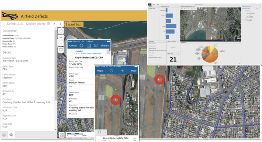
Cloud-based geospatial platform
Woolpert developed a cloud-based geospatial solution, spatially-enabling maintenance processes. This included:
- Web mapping– Providing a spatially-dynamic view of the airport’s past and present data while tracking risks and defects
- Dashboard– Esri’s ArcGIS Dashboard app displays analytics and visual reports allowing management to easily view and report defects and safety issues
- Notifications– Direct email notifications enable management to track issues’ statuses.
- Mobile collection app– Airport operators could capture and report defects and safety risks in real time.
- Geocirrus– Providing secure user access and data and software hosting, as well as web mapping, editing and reporting tools.
The Results
Improved safety and reduced operational risk
Woolpert’s Wellington Airport Runway Defect system provides WIAL with full GIS operations capability without requiring costly infrastructure. This solution streamlines workflows and improves airport safety by:
- Improving management control and issue resolution through ongoing tracking
- Reducing operational risk through analytics to review past trends and predict future issues
- Capturing spatially-enabled pavement, wildlife and FOD issues in real-time
- Providing managers and operators with a visual interface allowing full data management