OVERVIEW
Our Aerial Survey Products
We are one of the Asia-Pacific region’s most experienced and tech-capable aerial surveying companies.
We began performing aerial surveys in the Asia-Pacific region over 60 years ago. Our aerial technologies include topographic LiDAR and digital cameras allowing us to deliver orthomosaics and terrain data sets of large land areas quickly with resolutions ranging from 5 to 30cm.
Capturing and delivering aerial data is a complex undertaking that requires a high level of expertise from many professionals. When you work with Woolpert for your airborne survey needs, you’re working with a team that combines decades of experience with an unmatched capability to carry out large, complex aerial mapping jobs precisely.
With a fleet of 10 aerial survey aircraft equipped with a range of digital aerial cameras and airborne LiDAR systems, our airborne operations team can tackle any aerial survey project at any location. We deliver fit-for-purpose solutions for your enterprise GIS or engineering requirements.

Airborne Imagery Survey
At Woolpert, our airborne imagery survey service isn’t just about handing over data. We show you what you can do with the information you’ve got. Our main aim is to help you make quick, informed choices based on true facts, not just guesses.
You can rely on our skill to provide aerial mapping and airborne imagery insights. We assist you in connecting different data sets, pinpointing the best solutions, and making swift decisions.

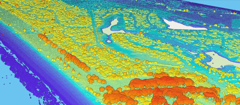
Aerial LiDAR Survey
Woolpert’s Aerial LiDAR surveying provides the data you need quickly, eliminating unnecessary delays and facilitating prompt action.
Our focus is ensuring you receive data that is precise and suitable for your specific needs. We help you pinpoint the right type and level of detail in your LiDAR data to make decisions with confidence.
WHAT WE HAVE DONE
Related Case Studies
Learn about how we’ve taken our surveys to deliver actionable intelligence on the ground for our clients.
Tags: aerial mapping, aerial lidar, airborne lidar survey, drone aerial imagery, aerial survey companies, lidar mapping services, high resolution aerial imagery, oblique aerial imagery, 3d aerial mapping, lidar aerial mapping, aerial imagery resolution, orthophoto drone, aerial topography, geospatial aerial imagery, aerial mapping drone, lidar survey data, airborne laser scanning, aerial mapping software, lidar image, aerial laser scanning, drone terrain mapping, aerial mapping camera, uav aerial mapping, lidar scan data, aerial lidar scanning, aerial lidar systems, aerial imagery providers, up-to-date aerial maps, aerial imagery analysis, drone lidar mapping.


