


Thanks to AAM, the sheep and beef industries are able to use and compare their own paddock data with government data in a consistent and interactive way—improving their pastoral and natural resource management.
AAM, working with CRC for Spatial Information and Rangelands NRM Alliance, developed the NRM Spatial Hub. Now, rangeland farmers have access to spatial data and tools to map, plan, analyse and monitor their properties infrastructure, land resources and ground cover.
Using the NRM Spatial Hub, land owners can more easily tackle soil loss through erosion, sustainable production and native vegetation management in each of the 12 Natural Resource Management Regions across Australia. Erosion is one of the most common and costly issues facing Australian farmers, and preventing it is critical to sustainable farming practices.
Read the full report: http://www.nrmhub.com.au/wp-content/uploads/2016/07/NRMHUB_Publish_Report-Final-1-1.pdf
NRM Spatial Hub gives farmers access to all the benefits that come from the latest spatial information systems, which use remote sensors and geospatial tools and data. The hub delivers these technologies in a user friendly, up-to-date spatial solution.
A recent survey of NRM Spatial Hub users revealed
- 90% of respondents found the NRM Spatial Hub easy to use
- 95% expect the NRM Spatial Hub will measurably improve property productivity, profitability and sustainability
- More than 50% foresee the NRM Spatial Hub will save between 10 and 30 labour days a year
- 75% anticipate measurable increases in safe carrying capacity through better pasture utilisation
- 72% rate this type of technology as important to making their business both viable and sustainable in the future
(Source: NRM HUB)
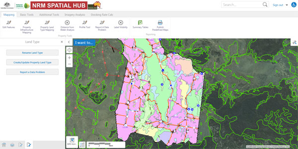
NRM hub’s easy to use inferface makes land management more effective.
 (1)")
")
")
")
")
")